My little Sanyo camera also takes videos. The actual quality is much higher than what you get when you post to YouTube, the these will give you an idea of beautiful area we backpacked in.
The view from our campsite. It was kind of early, so when I get the camera pointed east there is a pretty serious exposure problem...
The view from the top of Kings Peak. I think I was suffering from oxygen debt when I narrated the view from the peak. What I called Yellowstone Basin is actually Painter Basin, and the basin I didn't know the name of is the Yellowstone River Drainage.
Showing posts with label hiking. Show all posts
Showing posts with label hiking. Show all posts
Sunday, August 17, 2008


Saturday, August 16, 2008
On Top Of Utah - Kings Peak
Brennan and I capped off our summer with a fantastic 3-day backpacking trip to Kings Peak; the highest point in Utah.

We started at the Henry's Fork Trailhead at about 11:00 AM on Monday. We proceeded to put in an 8 hour day of backpacking, hiking about 12 miles and over Gunsight Pass into Painter Lakes Basin.
This was the view outside our tent the next morning.
On Tuesday we hiked up to Anderson Pass, and then started the 0.8 mile boulder scramble to the top of the peak. I had figured we could make that portion of the hike in about an hour, but in the end I think it took us closer to two hours.
There were a number of people up on top when we got there, so we asked a volunteer to snap this picture for us.
We only stayed on top for a few minutes. Recognizing that the east face was really not that much steeper than the north ridge, we made a bee line down the east face and back to the meadow below the peak. I think that saved us about an hour of hiking time.
We got back to our campsite at about 4:00 PM, so we decided to pack everything up and head back into Henry's Fork Basin. We went back over Gunsight Pass and headed north for Dollar Lake. We camped about 1/2 a mile to the south east of the lake.Neither of us slept well that night, so we were up by 6:00; packed and on the trail by 7:00. By 11:30 we were back at the trailhead and looking forward to lunch at the Pizza Hut in Mountain View, WY.
More PicturesYou can visit my Flickr Page for more pictures from this trip, including a critter, some wildflowers, and an unusually happy teenager.
We really hiked in an aggressive manner, putting in long days. If you have 4 or 5 days I would recommend spending the first night in Henry's Fork Basin, then crossing the pass on the second day and camping in Painter Lakes Basin. In fact, there are a number of pretty and secluded lakes in Henry's Fork Basin so you could spend several days there prior to crossing over. A key advantage of taking extra days would be that you would be better acclimatized when you actually attempt the peak.
There are a couple of short-cut routes to the base of the peak. In fact our campsite sat near a spring on one of the longer short-cuts. Most of the shortcuts involve significant boulder hopping or scree slope navigation. I am not sure that the savings in distance equal any savings in time unless you have experience navigating that kind of terrain.
Monday, October 29, 2007
San Rafael Knob Hike
Last weekend was my scout troop's annual trip to the San Rafael Swell. Usually we do a slot canyon hike with great narrows and sculpted sandstone like this:

 This year we have been working on the Hiking merit badge which requires the scouts to do five 10 mile hikes in preparation for a 20-miler. Most of the slot canyon hikes are shorter than 10 miles even if you do a loop of two canyons. In order to do a 10-miler we settled on a hike in the vicinity of Devils Canyon and the San Rafael Knob.
This is more of an open country hike. It's hard to imagine how anyone ever scraped out a life in this arid high mountain desert.

Recreation in the Swell is a point of serious contention right now. The BLM recently released an updated management plan, and have closed some sensitive routes to vehicular travel. Even though I am primarily a cyclist and backpacker, I can see the allure of ATV recreation, especially in areas like the Swell. The area is crisscrossed by old ranching an mining roads. But when I see something like this, I can't help but feel that the ATV crowd deserves even more restrictions unless they can find a way to police their own.
 The blatant abuse of a posted Wilderness Study Area is very offensive to me. There are literally hundreds of miles of trails and roads open in the Swell. The route closures should absolutely be honored.
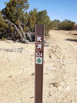
Then again, some of these signs aren't the clearest route markers in the world.
The San Rafael Knob is the highest point in the swell. From where we started it would have been a 12-14 mile round trip, so this is as close as we got.
 All in all, it was a nice hike. It helped that I had some of my best friends along as adult leaders.
On the way back to camp we tagged two great geocaches. If you are in the are you have to try and find Where in the Swell Am I and If you don't, Hoo Doo?. There are a lot of caches in the area, but many are much easier to find if you have an ATV to get you closer.

 This year we have been working on the Hiking merit badge which requires the scouts to do five 10 mile hikes in preparation for a 20-miler. Most of the slot canyon hikes are shorter than 10 miles even if you do a loop of two canyons. In order to do a 10-miler we settled on a hike in the vicinity of Devils Canyon and the San Rafael Knob.
This is more of an open country hike. It's hard to imagine how anyone ever scraped out a life in this arid high mountain desert.

Recreation in the Swell is a point of serious contention right now. The BLM recently released an updated management plan, and have closed some sensitive routes to vehicular travel. Even though I am primarily a cyclist and backpacker, I can see the allure of ATV recreation, especially in areas like the Swell. The area is crisscrossed by old ranching an mining roads. But when I see something like this, I can't help but feel that the ATV crowd deserves even more restrictions unless they can find a way to police their own.
 The blatant abuse of a posted Wilderness Study Area is very offensive to me. There are literally hundreds of miles of trails and roads open in the Swell. The route closures should absolutely be honored.
Then again, some of these signs aren't the clearest route markers in the world.

The San Rafael Knob is the highest point in the swell. From where we started it would have been a 12-14 mile round trip, so this is as close as we got.
 All in all, it was a nice hike. It helped that I had some of my best friends along as adult leaders.
On the way back to camp we tagged two great geocaches. If you are in the are you have to try and find Where in the Swell Am I and If you don't, Hoo Doo?. There are a lot of caches in the area, but many are much easier to find if you have an ATV to get you closer.
Subscribe to:
Posts (Atom)

 Subscribe to the RSS feed.